Posts

Showing posts from December, 2024

LETEL: Providing You With Exceptional Drone Mapping Solutions
Image
Are you looking for a LiDAR company that can provide you with the best services? You should choose the one that relies on the latest technology and provides you with unmatched expertise. One company that you can trust is LETEL. It has been providing innovative solutions that benefit various industries. It was first founded in the year 2018. Since then, it has been offering efficient solutions that help with various challenges in different sectors. So, whether you are working in the construction industry or any other industry, you can benefit from choosing this company. It has a highly passionate team that believes in collaboration and delivering the best at all times. Let’s discuss more about it.  Precision in data capture The team of LETEL understands that it can be difficult to get the best solutions when you are working in challenging locations. However, it will rely on precise data capture technology that provides accurate solutions in all types of locations. It o...

Top 4 Surveying Systems Used in Creating Top-Class Digital Terrain Models

Image
A top-notch Digital Terrain Model (DTM) requires accurate data and sophisticated survey systems. A DTM serves as a 3D representation of the earth's surface. It is used in construction, mapping, flood assessments and other projects. Enlisting the survey tools ensures accuracy and trustworthiness. Below are four leading survey systems in fabricating terrain models .  Accurate Construction Surveys Accurate construction surveys play a role in ensuring a successful plan and execution of construction projects. In construction surveys, using tools like stations and GPS receivers to measure distances and angles effectively is common. This data is processed into a DTM (Digital Terrain Model) to ensure the construction work alignswith the intended design seamlessly.These survey tools play a role in preventing mistakes or the need for additional work during the construction process. Drone Surveying Drone surveying is transforming the surveying industry. It offers cost-efficien...

Step-by-Step Assistance by Drone Services to Construction Contractors

Image
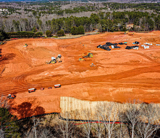
Construction contractors depend on other service providers to complete the project. Usually, contractors with in-house resources do not need outer assistance. However, the ones trying to operate their business efficiently utilize external services. For example, these contractors rent excavation trucks, grab & tipper trucks, operators, etc. Drone inspection services are another set of services that these contractors find useful. Here's how these services assist contractors throughout the construction process. Inspecting the Surroundings: No construction contractor starts the project right away. The process usually begins with analyzing the area. Smaller areas are easy to inspect, but larger ones are daunting. In these situations, contractors utilize drone services. They opt for a drone and efficient operator to provide an aerial view of the site. Drones can help carefully inspect the entire area. The contractors can zoom in and out for a detailed site view. Hence,...

Pioneering Lidar Mapping: How Letel Stands Out as a Leading Lidar Company

Image
Technological advancement reformulates the way industry functions, and it goes the same for lidar mapping companies. Lidar mapping has evolved with a technological approach to acquire accurate data and analytics. This mapping is an innovative method that utilizes laser technology to create the most detailed three-dimensional representations of the Earth's surface. This press release covers one such company that remains ahead of the rest in the race for excellence and reliability of lidar technology.    LETEL is an innovative company that specializes in lidar mapping. It utilizes sophisticated laser technology and drone surveying techniques for highly detailed information about the area. The company is committed to innovation and quality. It offers accurate and high-resolution data collection services that are designed to meet diverse needs such as construction, mining, and environmental studies. The company is dedicated to maximizing aerial mapping effectiveness ...

Understanding The Art Of Drone Surveying

Image
Are you searching for drone surveying solutions? Drone surveying helps improve efficiency as it helps capture detailed data. Technology has evolved with time and drones have become an important part of surveying solutions. Therefore, you should choose a drone surveying service to get the best solutions for your property. The professionals providing the services do not only fly the drone but also deliver great value to all clients. Let’s discuss more about the art of drone surveying                                                     Drone surveying: How it helps Drone surveying is the process of collecting data for different purposes such as mapping, etc. It is beneficial for fields like construction, mining, real estate, etc. These drones have advanced features that make it easier to get quality images. With these maps, one can make ...

Drone Services: Facilitating Better Site Management with an Aerial View

Image
Site management is one of the jobs for project managers. These professionals ensure that every part of the project adheres to the plan. Manual site management without tech resources is time-consuming, error-prone, and tedious. However, none of the professionals have to undergo the same manual procedures. Instead, they can trust drone inspection services to conduct their jobs better. Here's how these services facilitate improved site management.                                                             Allows to Inspect Consistently: Every on-field project manager keeps a constant eye on the current status. Drones help them stay informed perpetually. Drone services have marked a remarkable pr...